Leeds University Digital Library
Skip to content
Skip to main navigation
Login
Search Library website
Digital Library home
About the
Digital Library
Search Digital Library
Digitisation Services
Home
Digital Services
Study and Research Support
Special Collections
Contact Us
Browse by Collections
Up a level
Export as
ASCII Citation
BibTeX
Dublin Core
EndNote
HTML Citation
METS
Object IDs
OpenURL ContextObject
RDF+N-Triples
RDF+N3
RDF+XML
Refer
Reference Manager
Atom
RSS 1.0
RSS 2.0
Group by:
Keywords
|
No Grouping
|
Title
|
Original object type
Dwellings
Leeds
Maps
Sanitation
Working Class
Yorkshire
Number of items:
6
.
Dwellings
, Sly, Steven.
(1840-1842)
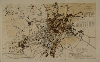
The map is called 'Sanitary Map of the Town of Leeds.'; title can be found in the top right corner. The map also contains a reference to public buildings and map-explanatory notes in the bottom right corner; and references to Wards, in Leeds and Selby, below the title of the map, in the top right corner. A scale of Yards is at the bottom end of the map.
[Image]
Preview
Leeds
, Sly, Steven.
(1840-1842)
The map is called 'Sanitary Map of the Town of Leeds.'; title can be found in the top right corner. The map also contains a reference to public buildings and map-explanatory notes in the bottom right corner; and references to Wards, in Leeds and Selby, below the title of the map, in the top right corner. A scale of Yards is at the bottom end of the map.
[Image]
Preview
Maps
, Sly, Steven.
(1840-1842)
The map is called 'Sanitary Map of the Town of Leeds.'; title can be found in the top right corner. The map also contains a reference to public buildings and map-explanatory notes in the bottom right corner; and references to Wards, in Leeds and Selby, below the title of the map, in the top right corner. A scale of Yards is at the bottom end of the map.
[Image]
Preview
Sanitation
, Sly, Steven.
(1840-1842)
The map is called 'Sanitary Map of the Town of Leeds.'; title can be found in the top right corner. The map also contains a reference to public buildings and map-explanatory notes in the bottom right corner; and references to Wards, in Leeds and Selby, below the title of the map, in the top right corner. A scale of Yards is at the bottom end of the map.
[Image]
Preview
Working Class
, Sly, Steven.
(1840-1842)
The map is called 'Sanitary Map of the Town of Leeds.'; title can be found in the top right corner. The map also contains a reference to public buildings and map-explanatory notes in the bottom right corner; and references to Wards, in Leeds and Selby, below the title of the map, in the top right corner. A scale of Yards is at the bottom end of the map.
[Image]
Preview
Yorkshire
, Sly, Steven.
(1840-1842)
The map is called 'Sanitary Map of the Town of Leeds.'; title can be found in the top right corner. The map also contains a reference to public buildings and map-explanatory notes in the bottom right corner; and references to Wards, in Leeds and Selby, below the title of the map, in the top right corner. A scale of Yards is at the bottom end of the map.
[Image]
Preview
![[feed]](/style/images/feed-icon-14x14.png) Atom RSS 1.0 RSS 2.0
Atom RSS 1.0 RSS 2.0


![[imga]](https://digital.library.leeds.ac.uk/820/1.hassmallThumbnailVersion/mattisonpoo_sanitarymapleeds.jpg)